Colorado Attractions
Attractions
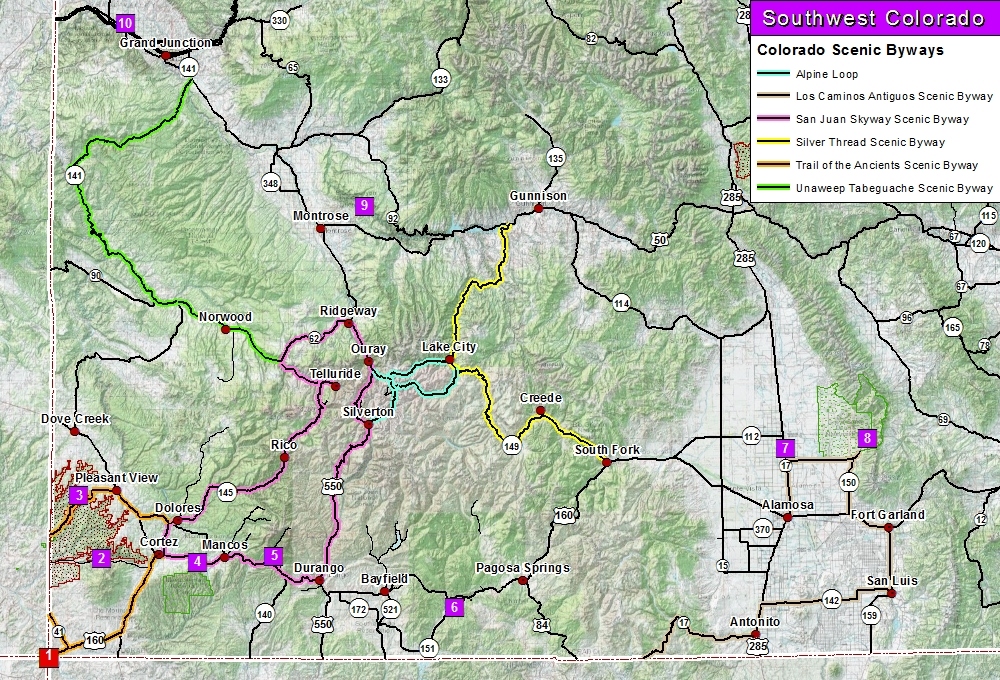
➠ Black Canyon of the Gunnison National Park (#9)
Google Map 156 miles
➠ Canyons of the Ancients National Monument (#2)
Google Map 96 miles
➠ Canyons of the Ancients Visitor Center and Museum (Dolores)
Google Map 80 miles
➠ Chimney Rock National Monument (#6)
Google Map 76 miles
➠ Colorado Gator Reptile Park (#8)
Google Map 175 miles
➠ Cortez
Google Map 77 miles
➠ Creede
Google Map 150 miles
➠ Dinosaur Journey Museum (#10)
Google Map 216 miles
➠ Dove Creek
Google Map 111 miles
➠ Durango Railroad, Museums, Honeyville, etc.
Google Map 36 miles
➠ Four Corners Monument (#1)
Google Map 76 miles
➠ Great Sand Dunes National Park (#7)
Google Map 200 miles
➠ La Plata Canyon Recreation Area (#5)
Google Map 51 miles
➠ Mancos
Google Map 60 miles
➠ Mesa Verde National Park (#4)
Google Map 80 miles
➠ Montrose
Google Map 143 miles
➠ Ouray
Google Map 105 miles
➠ Pagosa Springs
Google Map 86 miles
➠ Ridgway
Google Map 117 miles
➠ Silverton
Google Map 84 miles
➠ Telluride
Google Map 143 miles
Scenic Byways
(65 mile back country loop)
(129 mile highway)
(236 mile highway loop)
(Colorado Segment = 96 mile highway loop)
(Utah Segment = 200 mile highway loop)
(PDF 238 KB)
Old Spanish National Historic Trail

The Old Spanish National Historic Trail known as the "longest, crookedest, most arduous pack mule route in the history of America" runs through New Mexico, Colorado, Arizona, Utah, Nevada and California.
Four Corner's States
 |
 |
 |
 |
| Arizona | Colorado | New Mexico | Utah |
Hiking Trails
Southwest Colorado has a plethora of hiking trails scattered throughout the San Juan Mountains. Many of these trails offer breath taking views of peaks, lakes, and valleys as well as alpine fields of flowers and old mining history. So many trails yearning to be hiked and places to be photographed.
Horse Riding Trails
Southwest Colorado is famous for its trails which are scattered throughout the San Juan Mountains. Offering breath taking views of peaks, lakes, and valleys are an infinite number of trails begging to be trodden by the outdoor enthusiast. Among these countless trails are a growing number of trails for the horse riding enthusiast.
Mountain Bike Trails

Colorado is one of the world's premier mountain biking destinations. Within the Southwest region of Colorado, are numerous trails for the beginners to the experts.
Water Recreation
Within Southwest Colorado lies numerous lakes and reservoirs! Many are tucked away on some mountain road, while other are right next door to a metropolitan. Definitely a variety exists for the advid fisherman or bird watcher.➠ Southwest Colorado Water Recreation

Download Other Maps
| Alpine Loop Scenic Byway | ⇩ Print PDF | |
| Black Canyon of the Gunnison National Park | ⇩ Print PDF | ⇩ GPX file |
| Canyons of the Ancient | ⇩ Print PDF | ⇩ GPX file |
| Chimney Rock National Monument | ⇩ GPX file | |
| Durango-Silverton Narrow Gauge Railroad | ⇩ GPX file | |
| La Plata Canyon | ⇩ Print PDF | ⇩ GPX file |
| Los Caminos Antiguos Scenic Byway | ⇩ Print PDF | |
| Mesa Verde National Park | ⇩ Print PDF | ⇩ GPX file |
| San Juan Skyway Scenic Byway | ⇩ Print PDF | |
| Trail of the Ancients Scenic Byway | ⇩ Print PDF |
To Download a GPX file:
Internet Explorer: Right Click - Save Target As
Chrome/Firefox: Right Click - Save Link As
